In the summer of 1961, Dr. Robert Hatt, Director of Cranbrook Institute of Science (CIS) from 1935 to 1967, took a field trip to Africa to study small mammals in South Rhodesia (now Zimbabwe). Using his travel journals, photographs, and his published articles, we can follow his field work, analysis, and conclusions quite closely.
On his trip he kept one scientific journal and one for general observations from region to region, which provides a rich source for social, political, geographical, and anthropological insights into the region’s society.
Dr. Hatt and his wife, Sue, set off for Africa on July 1, 1961, traveling from New York to Dakar then through Ghana, Nigeria, and the Congo, arriving at the Atlantica Ecological Research Station (AERS) in Salisbury, (now Harare, Zimbabwe) on July 21st.

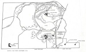
Upon arriving at Salisbury airport, they were met by Rudyerd and Louise Boulton. Rudyerd, an American ornithologist and the Director of AERS, had invited Hatt to undertake the study with financial support from the New York Zoological Society. Hatt began his field study journal at this point, writing,
“The house is charming, stone walled, 1 storey, good garden beyond. The lab building attached still under construction but RB had my desk set up and equipped—a dozen volumes on mammals in a book shelf, ready to work. RB & I went out with my collector, Kenny, and made an incomplete circuit of the property, setting 15 Sherman traps out near stream.”
Journal #44, Africa. Robert T. Hatt Papers (1999-14)

It is fascinating to see his research data in its raw form, which can be compared with his account in the CIS newsletter and a more formal and scientifically dense report in a published journal, later reproduced in Zoologica.
Hatt studied the small mammal population of Zimbabwe from July 21 until the beginning of September, similar to the research he conducted in Michigan and other regions (his doctoral dissertation was on a type of red squirrel). In Zimbabwe, he contributed to an understanding of the local fauna, which presents a nuisance to agriculture and animal husbandry.
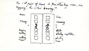
With assistance from his wife, he captured mice, rats, shrews, and elephant shrews which were measured, weighed, and marked in the ears with a serial number to recognize them if recaptured. In the first three weeks of field work, they had marked and released over 150 animals with 65 recaptures, some recaptured 3 or 4 times.

Hatt variously notes these small mammals as generally uncooperative with the study, and remarks,
“This matter of ear marking is not to the animal’s liking and despite my use of rubber gloves and plastic handling boxes, rare is the morning in which I am not given some identifying perforation of my own by their sharp teeth.”
Cranbrook Institute of Science Newsletter, Vol. 31, No. 2, October 1961, p.13

Hatt describes the landscape of the 150-acre Station as a combination of grassland and Brachystegia woodland, noting the prevalence of “picturesque kopjes” which provided good lookout sites and defensive structures for Bushmen and Bantu prior to the British colonial settlement of Salisbury in 1890. Most interesting are the “Bushmen paintings” that evidence early occupation of the area. One location, Somerby Farm, is recorded both photographically and in his manuscripts. This group of paintings indicates the presence of elephants, hippopotamus, buffalo, hartebeest, kudu, and reedbuck.

The Hatts left Salisbury on September 4th, heading first to Arusha, Tanzania; then to Nairobi, Kenya; Uganda; Khartoum, Sudan; and finally to London.
Hatt’s small journal includes his observations along the way and his comments include the cockroaches in their first hotel bathroom, types of trees, cocoa tree disease, termites, religious missions, types of goats, museums, meetings, markets (and what was for sale in them), local people, anthropological marks of beauty, and signs on shops and wagons. The latter include “Aim High,” “Do Good,” “Still it makes me laugh,” “Give all to God,” and “Forget me Not.”
One comment on his journey from the Ivory Coast to Accra made me smile, as I could relate to the experience of plane food:
“Our plane, DC-3, was “First Class” and we were obliged to pay $50 extra for upgrading our ticket (Nigerian Airways). All we got for it was one whiskey and a sandwich which I wouldn’t eat.”
Journal #43, Africa. Robert T. Hatt Papers (1999-14)

Often archives hold information on individuals, institutions, and society that were not the original purpose of the document, and this is true with Hatt’s Papers. His field journals yield rich information not only on his process of data collection and analysis, but they also provide a lot of description of human geography and regions that he visited, as well as biographical insights into Hatt himself. The CIS collections are a wonderful resource for many avenues of study, and we would welcome researchers to come and explore these wonderful and valuable resources.
—Laura MacNewman, Associate Archivist, Cranbrook Center for Collections and Research
Editor’s Note: This Sunday, join the Center for a fascinating discussion with Elizabeth Rauh, Assistant Professor, Modern Art and Visual Cultures, American University in Cairo for her talk, “Iraq en Route: A Photographic Journey, 1952-1953.” Rauh has conducted a year-long study into the photographs Dr. Hatt took on his 1952 trip to Iraq, and her presentation will weave together Hatt’s images with the history of both ancient and mid-twentieth century Iraq.
References
Hatt, Robert Torrens. The Mammals of the Atlantica Ecological Research Station, Southern Rhodesia, reprinted in Zoologica, Scientific Contributions of the New York Zoological Society, vol.48, issue 2, Summer 1963
Hatt, Robert Torrens. ‘Hunting Africa’s Smallest Game,’ Cranbrook Institute of Science Newsletter, Vol. 31, No. 2, pp.10-14